Showing 10 items matching county of ripon
-
 Federation University Historical Collection
Plan, Parish of Dowling Forest, County of Ripon and Grenville, 19
... Parish of Dowling Forest, County of Ripon and Grenville... Parish of Dowling Forest, County of Ripon and Grenville ...Scale [1:31 680]. 40 chains to 1 in.Geological map on a cadastral base, showing the occurence of reefs, and alluvial deposits. Relief shown by contours.dowling forest, wyndholm, wyndholm pre-emptive right, miners rest, ballarat racecourse, winter's swamp, police reserve, miner's rest, winters swamp, geology -
 Federation University Historical Collection
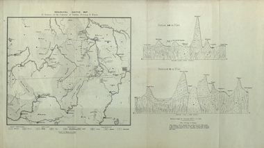
Map, Geological Sketch Map of of Dundas, Berung, and Ripon Counties
... county of ripon...Map of the Counties of Dundas, Berung, and Ripon..., and Ripon Counties Map of the Counties of Dundas, Berung, and Ripon ...Map of the Counties of Dundas, Berung, and Riponcounty of dundas, county of berung, county of ripon, map, geology, ararat, stawell, hamilton, grampians -
 Federation University Historical Collection
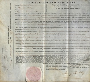
Document, Grant, by Purchase, Parish of Burrumbeet, Victoria, 1857
... county of ripon... roods and thirteen perches in the County of Ripon Parish..., two roods and thirteen perches in the County of Ripon Parish ...John Ettershank of Ballarat purchased land for Ninety-three pounds, two shillings and four pence. This was ten acres, two roods and thirteen perches in the County of Ripon Parish of Burrumbeet. The land sold at Ballarat as Lot No 37. The document was witnessed by Sir Henry Barkly, Knight Commander of the Most Honorable Order of the Bath, Captain-General and Governor-in-Chief of the said Colony and Vice-Admiral, at Melbourne, VictoriaThick cream paper, badly stained. Hand written Official seal Dated 16 April 1857 Signed: Henry Barkly -Governor-in-Chief of the Colony Signed: William C Haines - Chief Secretary and Registrarjohn ettershank, ballarat, county of ripon, parish of burrumbeet, sir henry barkly, captain-general, governor-in-chief -
 Stawell Historical Society Inc
Map, 1858
... County of Ripon... grampians Map County of Ripon Stawell ...County of Riponstawell -
 Federation University Historical Collection
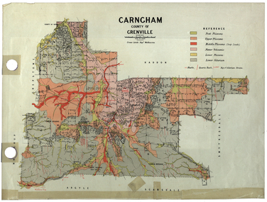
Plan, Carngham, County of Grenville
... county of ripon... carngham county of ripon county of grenville plan Crown Lands ...A plan of Carngham, Victoria.snake valley, timber reserve, poverty point, recreation reserve, carngham, county of ripon, county of grenville, plan -
Stawell Historical Society Inc
Map, 1959
... Bulgana, Counties of Borung & Ripon... grampians Map Bulgana, Counties of Borung & Ripon Stawell ...Bulgana, Counties of Borung & Riponstawell -
Stawell Historical Society Inc
Map, 1957
... Concongella South, Counties of Borung & Ripon... grampians Map Concongella South, Counties of Borung & Ripon Stawell ...Concongella South, Counties of Borung & Riponstawell -
 Federation University Historical Collection
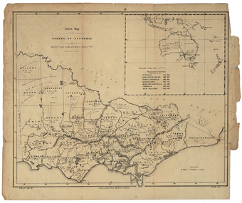
Map, Robert Brough Smyth, Sketch Map of the Colony of Victoria, c1871, c1872
This map includes the population of each County in Victoria according to the 1871 Census, as well as the population of each Australian colony and New Zealand. Telegraph Route is given in a detail at the top right. victoria, victorian counties, robert brough-smyth, telegraph, population, bourke, rodney, dalhousie, evelyn, mornington, buln-buln, tanjil, dargo, delatite, moira, bogong, bendigo, gunbower, grant, talbot, hampden, heytesbury, polwarth, ripon, kara-kara, gladstone, grenville, croajingolong, tambo, benambra -
 Federation University Historical Collection
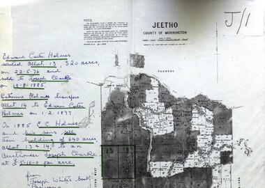
Documents, Documents relating to Land - Selection of Maps of subdivisions; Titles; Cemetery sections
... counties of ripon and talbot certificate of title ballaarat general ...Maps indicate the land owned in various areas of Victoria - Mornington Peninsula, Ascot / Creswick areaLand maps showing block divisions and ownersjeetho, county of mornington, edward carter holmes, joseph clarke, catherine holmes, talbot, william coghill, pre-emptive right, tourello pre-emptive right, glendonald pre-emptive right, clunes, smeaton, ascot, counties of ripon and talbot, certificate of title, ballaarat general cemetery, new cemetery -
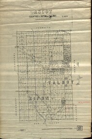 Federation University Historical Collection
Plan - map, Ascot: Counties of Ripon and Talbot, 18/12/1920
... Plan Ascot: Counties of Ripon and Talbot Maps parishes located ...Cadastral map showing parish boundaries and land ownership. "L5270"Maps parishes located in Ascot area. Photo-Lithographed at the Dept. of Lands and Survey.Highlighted parish labelled, Mrs E.C.Sutherland.parish, map, ascot, counties, e. c. sutherland, a. cameron, sweeney, w. j. clarke, mount hollowback, tourello, burrumbeet, glendaruel, dowling forest, a. j. mullett, w. j. butson, 1920, william coghill, chatham, chatham family collection, mrs e.c.sutherland.